
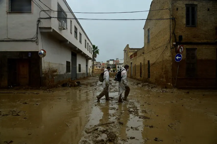
Heavy rainfall and flash flooding devastated the Valencia area last year. The sudden downpours killed over 200 people and destroyed towns, villages and infrastructure across the region.
It was one of the worst flood-related disasters in Europe since the late-1960s and the worst in Spain for many decades. For many it also introduced them to a new meteorological phenomenon: a ‘DANA.’
Almost exactly a year on, eastern Spain has been hit with another DANA (known as Alice) and the resulting storms have again caused torrential rain which led to floods in Alicante and Murcia, causing evacuations, road closures, and communication problems.
Floods also caused transport havoc on the island of Ibiza for the second time in as many weeks, and trapped travellers in their cars and homes in the northeastern Catalonia region over the weekend.
READ ALSO: Spanish Word of the Day: DANA
What is a DANA?
DANA is an acronym which stands for Depresión Aislada en Niveles Altos.
The official definition from Aemet, Spain’s state meteorological agency is: “A closed depression at high altitude which has become isolated and separated from jet stream circulation, and which moves independently of such a flow becoming, at times, stationary.”
In other words, a DANA is a very intense wind current that forms when it breaks away from a polar jet, a sort of pocket of cold air surrounded by warmer air that can move around and cause extreme weather episodes, as we saw so tragically in Valencia recently. It's the meeting of hot and cold air fronts causing extreme weather, essentially.
We don’t really have a direct translation into English, but DANAs can be best described as periods of heavy rain, stormy weather and a sudden drop in temperatures.
The greater the temperature difference, the greater the storm, hence why the worst DANAs are usually at the tail end of summer in September and October, and are more likely to happen in parts of southern and eastern Spain.
READ ALSO: MAPS: The places in Spain most at risk of recurring flash floods
Why do people in Spain say DANA rather than storm?
If you’re a Spanish speaker or have lived in Spain for a few years, you might be familiar with the term gota fría, literally meaning ‘cold drop’.
For many years this was the most common terminology used by Spaniards, and as such DANA is a relatively new concept. Why the change? Modern meteorologists believe the older gota fría is a vague term that, as technology develops and we gain greater scientific understanding of them, is becoming less useful.
As such, in the last decade or so DANA has increased in usage among scientists, the media and therefore Spaniards more generally as we understand more about ‘cold drops’ and what exactly causes a DANA. Simply put, DANA is a more specific term.
On its website, Aemet explains that: ‘The term gota frìa is a relatively old concept and has been superseded over the years. New ways of understanding tropospheric processes and new observational tools have made us revise and redefine the ideas linked to these isolated pockets of cold air at higher levels. We believe that the concept of DANA, which we associate with the Anglo-Saxon term ‘cut-off low’, is more accurate and realistic than that of gota fría. As the concept of a gota fría is not very precise and incomplete, it is understood that it should be replaced by a more modern one.”
Other words commonly used in Spanish to describe storms are borrasca and tormenta.
Are DANAs a Spanish weather phenomenon?
Not exactly. Though DANAs aren't a uniquely Spanish phenomenon, Spain’s geography and climate means it’s more susceptible to them than many parts of the world.
As DANAs form when masses of hot and cold air meet, they generally only happen in the east of the Atlantic, parts of the Mediterranean, and the east of the Pacific and Chinese coast.
South-eastern Spain is especially vulnerable to DANAs because it’s where the Atlantic and Mediterranean meet, meaning that cold air fronts can meet warm air fronts at certain times of year. Southeast Spain in particular is an area where mountains favour the formation of storm clouds and therefore rainfall.
Are DANAs becoming more common?
It certainly feels that way, with several DANA-like episodes in Spain in recent years. Of course, DANAs existed before, though not with that name, and Spain has experienced freak rainfall and flooding before, too, but scientists do seem to think that climate change could make them more likely.
Though scientists are often reluctant to draw a direct link between climate change and specific storm episodes, it seems many believe that climate change at the very least makes them worse when they do happen.
Friederike Otto, a climatologist at Imperial College London, told the BBC that “there is no doubt in our minds that these torrential, massive, explosive rains have been intensified by climate change.
“With every fraction of a degree of warming caused by fossil fuels, the atmosphere can hold more moisture, leading to more intense rain bursts."
Climate change causing rising sea temperatures in the Mediterranean, when combined with cooling air fronts coming in over the autumn, seem to make the DANAs more intense and perhaps also more common.
Some studies indicate that there's more rain during the heaviest rainfall days now than in past decades, so, although rainfall may be less frequent overall, they tend to be heavier and more destructive when it does rain.
READ ALSO: What do Spain's orange and red weather alerts mean for the public?
Comments