Heat warnings issued across Spain as nation sizzles
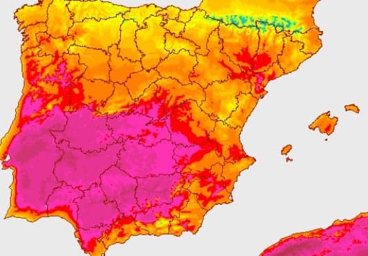
Eight regions have been issued with weather warnings on Tuesday as the mercury is expected to soar above 38C in much of Spain.
Spain’s meteorological agency AEMET has issued amber warnings for parts of the Canary Islands and yellow warnings across much of the south and centre of the peninsula.
25/08 09:01 #AEMET #FMA nivel naranja por temp. max para hoy en Canarias . . Imagen en vigor a las 09:01 (tabla actualizada haciendo CLIC EN LA IMAGEN), o visite https://t.co/aIJV7Dmn4O https://t.co/IvhgKnVS2D
— AEMET (@AEMET_Esp) August 25, 2020
"This last week of August is full on summer: clear skes, high temperatures and no rain,” explained Rubén del Campo, spokesman for Aemet. “And in the Canary Islands temperatures will be very high, at least until Thursday.”
The island of Gran Canaria could see the mercury top 43C.
The peninsula will be marked by sizzling temperatures and clear skies until Wednesday when the northern coast can expect some clouds and light rain although storms are expected to gather around the Pyrenees on Thursday.
This map shows that while Storm Francis batters the United Kingdom, Spain swelters in the heat with not a cloud above it.
Imágenes #METEOSAT canal IR de las últimas 12h. https://t.co/YbHiaSo4nH pic.twitter.com/wApeEXPcvA
— AEMET (@AEMET_Esp) August 25, 2020
By Friday the storms currently hitting northern Europe will hit Spain bringing torrential rain to northern parts of Spain sweeping east and reaching the Balearic Islands.
This new weather system will cause temperatures to plummet in the interior and north of Spain and the Pyrenees might even see a few flakes of snow.
The next graphic shows the forecast across Spain and the Balearic Islands until the weekend.
Tiempo previsto en Península y Baleares desde 24-08-2020 hasta 30-08-2020. Info siempre actualizada en https://t.co/keCWfwv3Ua pic.twitter.com/yaXQMsIXdG
— AEMET (@AEMET_Esp) August 24, 2020
Comments
See Also
Spain’s meteorological agency AEMET has issued amber warnings for parts of the Canary Islands and yellow warnings across much of the south and centre of the peninsula.
25/08 09:01 #AEMET #FMA nivel naranja por temp. max para hoy en Canarias . . Imagen en vigor a las 09:01 (tabla actualizada haciendo CLIC EN LA IMAGEN), o visite https://t.co/aIJV7Dmn4O https://t.co/IvhgKnVS2D
— AEMET (@AEMET_Esp) August 25, 2020
"This last week of August is full on summer: clear skes, high temperatures and no rain,” explained Rubén del Campo, spokesman for Aemet. “And in the Canary Islands temperatures will be very high, at least until Thursday.”
The island of Gran Canaria could see the mercury top 43C.
The peninsula will be marked by sizzling temperatures and clear skies until Wednesday when the northern coast can expect some clouds and light rain although storms are expected to gather around the Pyrenees on Thursday.
This map shows that while Storm Francis batters the United Kingdom, Spain swelters in the heat with not a cloud above it.
Imágenes #METEOSAT canal IR de las últimas 12h. https://t.co/YbHiaSo4nH pic.twitter.com/wApeEXPcvA
— AEMET (@AEMET_Esp) August 25, 2020
By Friday the storms currently hitting northern Europe will hit Spain bringing torrential rain to northern parts of Spain sweeping east and reaching the Balearic Islands.
This new weather system will cause temperatures to plummet in the interior and north of Spain and the Pyrenees might even see a few flakes of snow.
The next graphic shows the forecast across Spain and the Balearic Islands until the weekend.
Tiempo previsto en Península y Baleares desde 24-08-2020 hasta 30-08-2020. Info siempre actualizada en https://t.co/keCWfwv3Ua pic.twitter.com/yaXQMsIXdG
— AEMET (@AEMET_Esp) August 24, 2020
Join the conversation in our comments section below. Share your own views and experience and if you have a question or suggestion for our journalists then email us at [email protected].
Please keep comments civil, constructive and on topic – and make sure to read our terms of use before getting involved.
Please log in here to leave a comment.