Storm Bernard causes chaos in Spain with eight regions still on alert
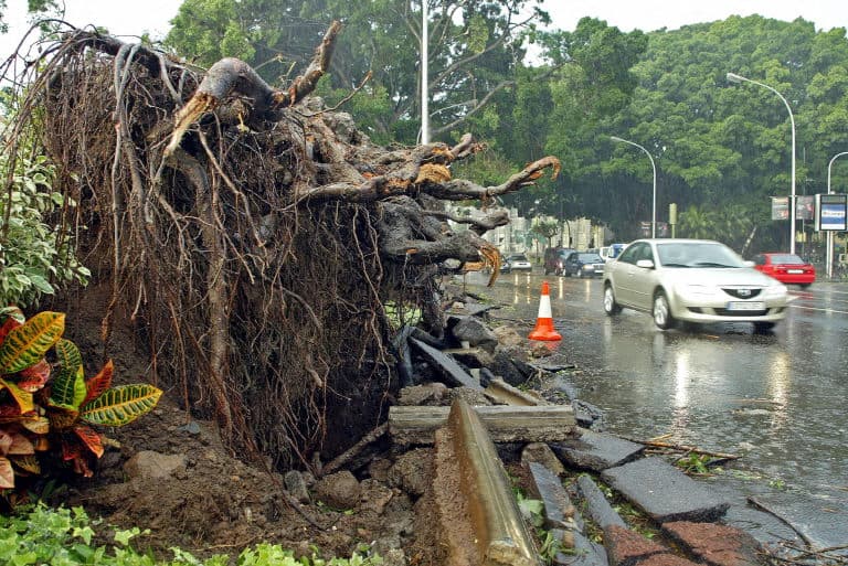
Eighteen provinces are on alert this Monday due to storm Bernard, which has already caused more than 1,500 incidences in the southern Andalusia region, where scores of trees have fallen due to 100km/h winds.
Spain’s State Meteorological Agency (AEMET) warned of 100-kilometre-per-hour wind, torrential rain and elevated waves across parts of the country on Monday, October 23rd.
Storm Bernard entered through the Gulf of Cádiz and has already begun to cross the Peninsula from south to north, wreaking havoc and leaving chaos in its wake.
In Andalusia, the Emergency 112 services attended more than 1,500 incidences between 3:00 p.m. and 10:00 p.m. on Sunday evening.
@Meteohuelva lo de Moguer y Palos ha sido criminal eh!#moguer #palos #meteo pic.twitter.com/hi0FosBQyC
— Pablo (@Pablouski19) October 22, 2023
Most of these were due to strong gusts of wind which caused trees and branches to fall, cables to break and signs and fences to tumble.
In Huelva, one person died when the vehicle in which he was travelling overturned after a landslide on the road.
#BorrascaBernard Feria de Bonares pic.twitter.com/BRmehRV0QD
— Daniel Medrano Ruiz (@rayo_danimedran) October 22, 2023
In the Granada town of Cuesta de Gomérez, a tree fell and injured three people, who were then evacuated to a local hospital, and in the city of Jaén, a woman injured her leg after a fence fell on her.
Several transport networks have also been disrupted including the train route between Lora del Río and Utrera (Seville) because of a fallen tree on the line and the N-IV road has been closed, at kilometre 570, in Utrera, because of a fallen palm.
La borrasca Bernard se lleva los tejados en Huelva pic.twitter.com/WolpNiAgHK
— Berbiqui (@Berbiqui) October 22, 2023
The province of Seville registered the highest volume of both incidences and warnings with almost 550 after 7:00 p.m. mainly due to wind.
Las imágenes que nos dejó ayer la #BorrascaBernard en Huelva son impresionantes. Se batieron varios récords entre ellos el de presión mínima medida con 988 hpa en una serie de 50 años.
Las rachas de viento superaron los 100 km/h. Los daños fueron cuantiosos.
Vía @Meteohuelva pic.twitter.com/e7pzO9btvz
— AMETSE (@MeteoSE) October 23, 2023
More warnings for Monday October 23rd
Aemet has predicted that Storm Bernard will have the greatest impact this Monday and has issued warnings to several regions.
Much of Castilla y León has been issued an orange level warning due to winds of more than 100 km/h.
Ten regions have also been given yellow warnings due to heavy rain, extreme wind and rough seas. These are Aragón, Andalusia, Cantabria, Castilla-La Mancha, Catalonia, Madrid, Navarra, Extremadura, the Basque Country and La Rioja.
Some of the worst affected provinces will be Lleida, Huesca, Zaragoza, Ávila, Soria, Guadalajara, Toledo, Lérida and Madrid, which could see up to 20 litres of rain per square metre in one hour.
AEMET has also forecast that snow level will be around 1,800/2,000 metres in the western Cantabrian Mountains and temperatures will drop in the western half of the Canary Islands.
On Tuesday, October 24th, even with uncertainty, the predictions point to a predominance of cloudy skies and rainfall in large areas, although less abundant than previously.
Comments
See Also
Spain’s State Meteorological Agency (AEMET) warned of 100-kilometre-per-hour wind, torrential rain and elevated waves across parts of the country on Monday, October 23rd.
Storm Bernard entered through the Gulf of Cádiz and has already begun to cross the Peninsula from south to north, wreaking havoc and leaving chaos in its wake.
In Andalusia, the Emergency 112 services attended more than 1,500 incidences between 3:00 p.m. and 10:00 p.m. on Sunday evening.
@Meteohuelva lo de Moguer y Palos ha sido criminal eh!#moguer #palos #meteo pic.twitter.com/hi0FosBQyC
— Pablo (@Pablouski19) October 22, 2023
Most of these were due to strong gusts of wind which caused trees and branches to fall, cables to break and signs and fences to tumble.
In Huelva, one person died when the vehicle in which he was travelling overturned after a landslide on the road.
#BorrascaBernard Feria de Bonares pic.twitter.com/BRmehRV0QD
— Daniel Medrano Ruiz (@rayo_danimedran) October 22, 2023
In the Granada town of Cuesta de Gomérez, a tree fell and injured three people, who were then evacuated to a local hospital, and in the city of Jaén, a woman injured her leg after a fence fell on her.
Several transport networks have also been disrupted including the train route between Lora del Río and Utrera (Seville) because of a fallen tree on the line and the N-IV road has been closed, at kilometre 570, in Utrera, because of a fallen palm.
La borrasca Bernard se lleva los tejados en Huelva pic.twitter.com/WolpNiAgHK
— Berbiqui (@Berbiqui) October 22, 2023
The province of Seville registered the highest volume of both incidences and warnings with almost 550 after 7:00 p.m. mainly due to wind.
Las imágenes que nos dejó ayer la #BorrascaBernard en Huelva son impresionantes. Se batieron varios récords entre ellos el de presión mínima medida con 988 hpa en una serie de 50 años.
— AMETSE (@MeteoSE) October 23, 2023
Las rachas de viento superaron los 100 km/h. Los daños fueron cuantiosos.
Vía @Meteohuelva pic.twitter.com/e7pzO9btvz
More warnings for Monday October 23rd
Aemet has predicted that Storm Bernard will have the greatest impact this Monday and has issued warnings to several regions.
Much of Castilla y León has been issued an orange level warning due to winds of more than 100 km/h.
Ten regions have also been given yellow warnings due to heavy rain, extreme wind and rough seas. These are Aragón, Andalusia, Cantabria, Castilla-La Mancha, Catalonia, Madrid, Navarra, Extremadura, the Basque Country and La Rioja.
Some of the worst affected provinces will be Lleida, Huesca, Zaragoza, Ávila, Soria, Guadalajara, Toledo, Lérida and Madrid, which could see up to 20 litres of rain per square metre in one hour.
AEMET has also forecast that snow level will be around 1,800/2,000 metres in the western Cantabrian Mountains and temperatures will drop in the western half of the Canary Islands.
On Tuesday, October 24th, even with uncertainty, the predictions point to a predominance of cloudy skies and rainfall in large areas, although less abundant than previously.
Join the conversation in our comments section below. Share your own views and experience and if you have a question or suggestion for our journalists then email us at [email protected].
Please keep comments civil, constructive and on topic – and make sure to read our terms of use before getting involved.
Please log in here to leave a comment.