Published: 9 Jun, 2023 CET.Updated: Fri 9 Jun 2023 13:43 CET
These maps will help you to understand Valencia. Photo: undertravelnow.or.crylater / Unsplash
From the growth of the city over the ages and its different neighbourhoods today, to its lost river and busiest areas, these maps will help you to understand the Spanish city of Valencia a little better.
Advertisement
The oldest map of Valencia
Like many big cities in Spain, Valencia has had a long and significant history. Founded in 138 BC by the Romans, Valencia has had various names and has of course grown in size since then. For seven centuries it was part of the Islamic Empire (when it was known as Balansiya) before being united with the rest of Spain as part of the Reconquista in the 13th century.
Much later, Valencia experienced an economic and cultural boom, becoming the centre of the silk trade. The University of Valencia was founded back in 1499, even before the first known map, according to the town hall, which as printed in 1695.
This map shows the approximate location of the old Christian, Arab and Roman walls of the city of Valencia. The line in yellow shows the approximate location of the old Roman walls and the outline of the city that the Romans had called Valentina, because of its bravery. Historians believe it had two main streets and four gates. The place where these two streets crossed is the current Plaza de la Almoina.
During the Arab rule, the city grew and new walls were built, as seen in red. The construction of this wall began in the 11th century. With the fall of the Caliphate of Córdoba, Valencia became the capital of the Taifa of Valencia. The Arab wall surrounded the city and had a total of seven gates. The parts of the wall marked in black are what remains of this wall today.
The Christian wall, marked in blue, made the city bigger still. It was built in 1356 and had a perimeter of four kilometres with a total of 12 gates, four main ones.
Valencia's old city walls have helped shape the city today. Photo: Falconaumanni / WikiCommons
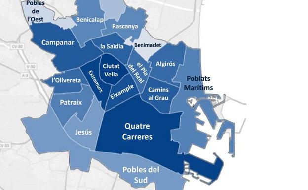
Today, Valencia is made up of 19 different districts
Valencia consists of several different barrios (neighbourhoods) spread out across the city, and is split up into 19 different districts. They are Cuitat Vella, which is the old town; Eixample, Extramurs, Campanar, La Zaidia and El Pla de Real, which we can consider part of the heart of Valencia. Finally, there's L'Olivereta, Patraix, Jesús, Quatre Carreres, Poblats Maritims (which includes the picturesque coastal barrio El Cabanyal), Camins al Grau, Algirós, Benimaclet, Rascanya, Benicalap, Pobles del Nord, Pobles de l'Oest, and Pobles de Sud, which make up the outer-lying neighbourhoods.
Photo: Ajuntament de València
Advertisement
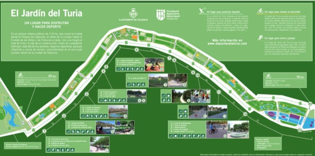
Valencia's lost river
If you've ever visited Valencia, you will probably be familiar with the Turia Gardens: the long park that runs around the centre of Valencia, all the way to the coast. This park in fact used to be a river - El Turia.
In 1957, the river burst its banks and flooded large swathes of the city, killing 81 people. Following the flood, the Valencian government decided to reroute the Turia and it was drained and rerouted to avoid the city, as can be seen in this map below.
After the river was drained, the dried-out riverbed was used as the location for the city's main park - El Jardín del Turia (the Turia garden), which is a long, winding park that runs around the old town down towards the coast, via the City of Arts and Sciences.
The park is incredibly popular with runners and cyclists and has several sports pitches spread throughout its long green snake-like space.
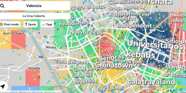
You've probably already made up your mind about certain areas of Valencia, but these are words that residents of the city have used to describe various neighbourhoods.
It was created by Hoodmaps, which features many maps of cities all over the world. It lists words like ‘universitarios' for the Benimaclet area where Valencia's students tend to live, and 'gentrification' and 'hipster beards' for Russafa, Valencia's hipster neighbourhood.
Photo: Hoodmaps
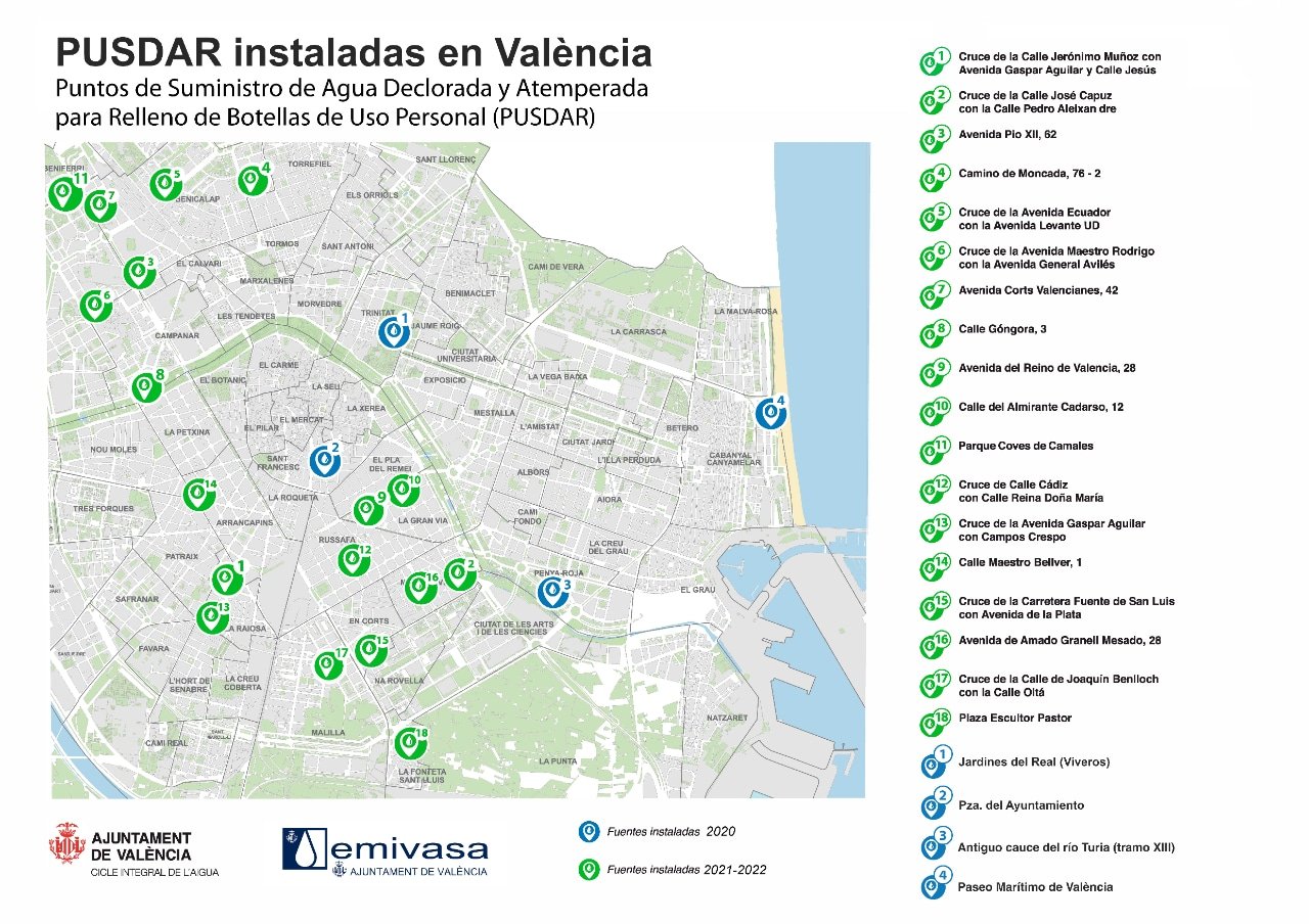
The city fountains where you can get cold potable water
Did you know that Valencia has 22 public fountains that filter and cool drinking water? Since 2020, the Valencia City Council has installed more than 20 fountains with the aim of combating the heat, as well as limiting the production of plastic bottles. This means that instead of buying bottles of water the next time you visit the city or you're out for a run, you can simply take your own bottle to refill.
There are many fountains across Valencia where you can get cold drinking water. Source: Ajuntament de Valencia
Advertisement
Some neighbourhoods are busier than others
The Valencia City Council published a study on mobility in the city in a bid to work out exactly how many people were moving about each neighbourhood every day and which were the busiest. Contrary to what many tourists may believe, it's not the old town neighbourhood of Ciutat Vella that receives the most footfall.
The map below shows that Quatre Carreres is the busiest district in Valencia (by any means of transport, even on foot) with almost 41,000 daily trips, which represents 13.2 percent of the total journeys that take place in the city. This high mobility could be down to the fact that this is the location of Valencia's famed City of Arts and Sciences. This is followed by Camins al Grau, which with 22,995 daily journeys and 7.7 percent of the total. In the city centre, the districts of Eixample (22,107) and Ciutat Vella (20,787) rank in third and fifth place, respectively.
These are the busiest and quietest districts in Valencia. Source: Ajuntament de Valencia
Advertisement
Bike paths
Despite being Spain's third-largest city and having a population of just over 800,000, Valencia is actually quite small and self-contained. As a result, and in addition to its flatness, it's a cyclist's dream. Valencia has a grand total of 160 kilometres of bike lanes, that stretch all the way around the Old Town, along the Turia Gardens and down to the beach.
City of Arts and Sciences
If you google 'Valencia', it's likely that the first thing you'll see is the futuristic-looking structures of the City of Arts and Sciences. It's one of Valencia's main tourist attractions and one of the largest scientific and cultural complexes in Europe. It has an area of 350,000 square metres, and has been conceived as a city within the city.
It was inaugurated in 1996 and the eye-catching designs of local Valencian architect Santiago Calatrava, make it look almost otherworldly. The complex includes a science museum, aquarium, concert hall, gardens and an exhibition centre.
Join the conversation in our comments section below. Share your own views and experience and if you have a question or suggestion for our journalists then email us at [email protected].
Please keep comments civil, constructive and on topic – and make sure to read our terms of use before getting involved.
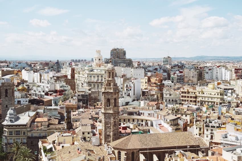
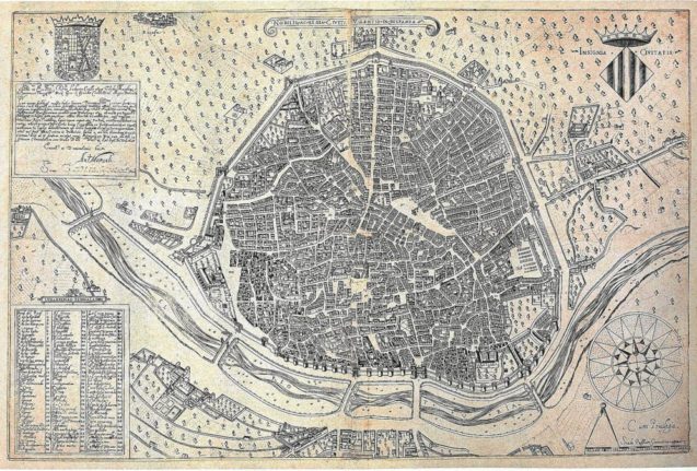
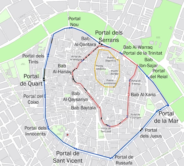
 Photo: Ajuntament de València
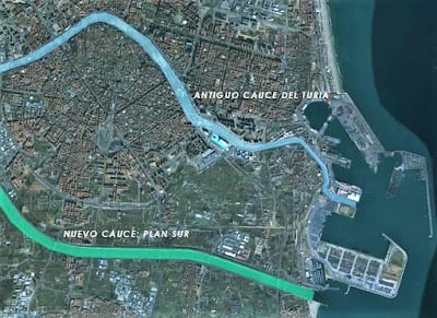
 There are many fountains across Valencia where you can get cold drinking water. Source: Ajuntament de Valencia
Some neighbourhoods are busier than others
The Valencia City Council published a study on mobility in the city in a bid to work out exactly how many people were moving about each neighbourhood every day and which were the busiest. Contrary to what many tourists may believe, it's not the old town neighbourhood of Ciutat Vella that receives the most footfall.
The map below shows that Quatre Carreres is the busiest district in Valencia (by any means of transport, even on foot) with almost 41,000 daily trips, which represents 13.2 percent of the total journeys that take place in the city. This high mobility could be down to the fact that this is the location of Valencia's famed City of Arts and Sciences. This is followed by Camins al Grau, which with 22,995 daily journeys and 7.7 percent of the total. In the city centre, the districts of Eixample (22,107) and Ciutat Vella (20,787) rank in third and fifth place, respectively.
There are many fountains across Valencia where you can get cold drinking water. Source: Ajuntament de Valencia
Some neighbourhoods are busier than others
The Valencia City Council published a study on mobility in the city in a bid to work out exactly how many people were moving about each neighbourhood every day and which were the busiest. Contrary to what many tourists may believe, it's not the old town neighbourhood of Ciutat Vella that receives the most footfall.
The map below shows that Quatre Carreres is the busiest district in Valencia (by any means of transport, even on foot) with almost 41,000 daily trips, which represents 13.2 percent of the total journeys that take place in the city. This high mobility could be down to the fact that this is the location of Valencia's famed City of Arts and Sciences. This is followed by Camins al Grau, which with 22,995 daily journeys and 7.7 percent of the total. In the city centre, the districts of Eixample (22,107) and Ciutat Vella (20,787) rank in third and fifth place, respectively.
 These are the busiest and quietest districts in Valencia. Source: Ajuntament de Valencia
Bike paths
Despite being Spain's third-largest city and having a population of just over 800,000, Valencia is actually quite small and self-contained. As a result, and in addition to its flatness, it's a cyclist's dream. Valencia has a grand total of 160 kilometres of bike lanes, that stretch all the way around the Old Town, along the Turia Gardens and down to the beach.
City of Arts and Sciences
If you google 'Valencia', it's likely that the first thing you'll see is the futuristic-looking structures of the City of Arts and Sciences. It's one of Valencia's main tourist attractions and one of the largest scientific and cultural complexes in Europe. It has an area of 350,000 square metres, and has been conceived as a city within the city.
It was inaugurated in 1996 and the eye-catching designs of local Valencian architect Santiago Calatrava, make it look almost otherworldly. The complex includes a science museum, aquarium, concert hall, gardens and an exhibition centre.
These are the busiest and quietest districts in Valencia. Source: Ajuntament de Valencia
Bike paths
Despite being Spain's third-largest city and having a population of just over 800,000, Valencia is actually quite small and self-contained. As a result, and in addition to its flatness, it's a cyclist's dream. Valencia has a grand total of 160 kilometres of bike lanes, that stretch all the way around the Old Town, along the Turia Gardens and down to the beach.
City of Arts and Sciences
If you google 'Valencia', it's likely that the first thing you'll see is the futuristic-looking structures of the City of Arts and Sciences. It's one of Valencia's main tourist attractions and one of the largest scientific and cultural complexes in Europe. It has an area of 350,000 square metres, and has been conceived as a city within the city.
It was inaugurated in 1996 and the eye-catching designs of local Valencian architect Santiago Calatrava, make it look almost otherworldly. The complex includes a science museum, aquarium, concert hall, gardens and an exhibition centre.
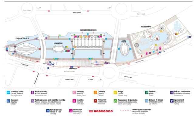 Photo: Ciutat de les Arts i les Ciències
Join the conversation in our comments section below. Share your own views and experience and if you have a question or suggestion for our journalists then email us at [email protected].
Please keep comments civil, constructive and on topic – and make sure to read our terms of use before getting involved.
Please log in here to leave a comment.