Published: 25 Feb, 2023 CET.Updated: Mon 27 Feb 2023 09:28 CET
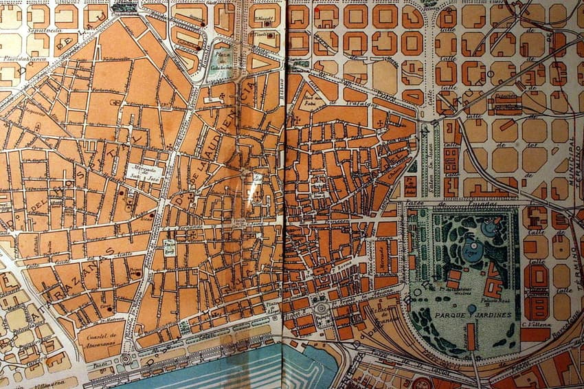
Map of Barcelona's Ciutat Vella (old town) in 1891. Maps can give you a greater understanding of a place's history and society and these tell an interesting story. Map: Public Domain/Wikipedia
From its origins to its urban expansion, its foreign residents and its beaches, these 11 maps will help you to understand the Catalan capital that little bit better.
Advertisement
Which neighbourhoods are truly part of Barcelona city?
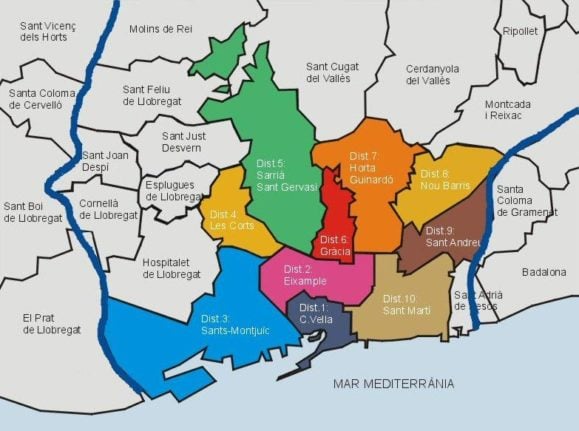
Barcelona has many different barrios (barris in Catalan, neighbourhoods in English), which are all located within 10 different city districts.
These are Ciutat Vella or the old town; Eixample, the modern extension of the old town; Sants-Montjuïc; Les Corts; Sarrià-Sant Gervasi; Gracia; Horta-Guinardó; Nou Barris; Sant Andreu and Sant Martí.
Everything outside of these areas may be part of the province of Barcelona but is not actually technically part of the city itself. Santa Coloma de Gramenet and Badalona for example are separate towns.
Barcelona is made up of 10 different districts. Source: Ajuntament de Barcelona
Barcelona lies between two rivers
The city actually lies between two rivers - the Llobregat to the south and the Besos to the north. These rivers actually mark the official boundary of the city limits.
Advertisement
For example, if you cross the River Besos, you will no longer be in Barcelona, you will be in Santa Coloma de Gramenet or Sant Adriá de Besós instead. Both rivers have pathways on either side where you can run, walk or cycle.
Barcelona is built between two rivers. Source: l'AMB
The city was originally founded by the Romans
Although the first human settlements in Barcelona date back to Neolithic times, the city was originally founded by the Romans around the end of the 1st century BC.
They called it Barcino and it was a settlement of around 1,000 inhabitants surrounded by stone walls. It was centred around the Forum and the Temple of Augustus, which you can still see today, near the Cathedral.
Roman Barcelona, known as Barcino. Source: Ajuntament de Barcelona
One foreign nationality (or two) stands out
As you probably know already, Barcelona is very multicultural. The map below shows which are the most populous nationalities in each district after Spanish.
And as you can see, Italians make up the majority of foreigners across most corners of Barcelona.
However, many Italians in Barcelona are in fact of Argentinian origin who get easy access to Italian passports and thus EU residency due to their Italian heritage. So the sea of blue is in fact a mix of Italians and Argentinians.
Chinese people also make up a large percentage of foreigners in Barcelona. They tend to live in the cheaper outer-lying neighbourhoods as well as in the central area around Fort Pienc. This is Barcelona's unofficial Chinatown with several Chinese supermarkets, banks, hairdressers, bubble tea shops and of course restaurants.
The most frequent nationality in each district of Barcelona, after Spanish. Source: Ajuntament de Barcelona
Barcelona actually has a natural park within its city limits
Barcelona isn't all concrete and there is a natural park within the city limits - the Parc de Collserola.
It measures over 8,000 hectares (seventeen kilometres long and six kilometres wide) and is filled with hiking and mountain bike paths, and is home to lots of wildlife, including wild boar. Public transport can also easily take you to other natural parks within the Barcelona province, including the Parc de la Serralada de Marina and the Parc Natural de Garraf.
The Collserola is a natural park within the city of Barcelona. Source: parccollserola.net
The city is home to eight different beaches
You're never that far from a beach in Barcelona as there are a total of nine of them within the city.
These range from the more touristy ones such as Barceloneta and Nova Icaria to Platja de Bogatell, loved by volleyball players and the nudist and LGBTQ+-favoured beach of Mar Bella.
Barcelona's eight beaches together with the Fòrum bathing area at the very end of the map. Source: Javiergp89/Wikipedia
Barcelona residents love their takeaways
The city streets are filled with Glovo and Just Eat drivers these days as Barcelona is enjoying takeout more and more. An increasing number of restaurants are also joining the trend.
Advertisement
Just Eat actually created this map which shows each district of Barcelona and what their favourite takeout cuisine is. In first place is Japanese, being preferred by six districts, but the most popular dish from these Japanese restaurants is Chinese spring rolls.
Those in Sarrià-Sant Gervasi prefer pad thai, whereas those in the Ciutat Vella like Chinese fried rice. There is only one district that hasn't put Asian food on the top of its list and that is Horta-Guinardó, where people prefer kebabs.
Which takeaway dish does each district in Barcelona prefer? Source: Just Eat
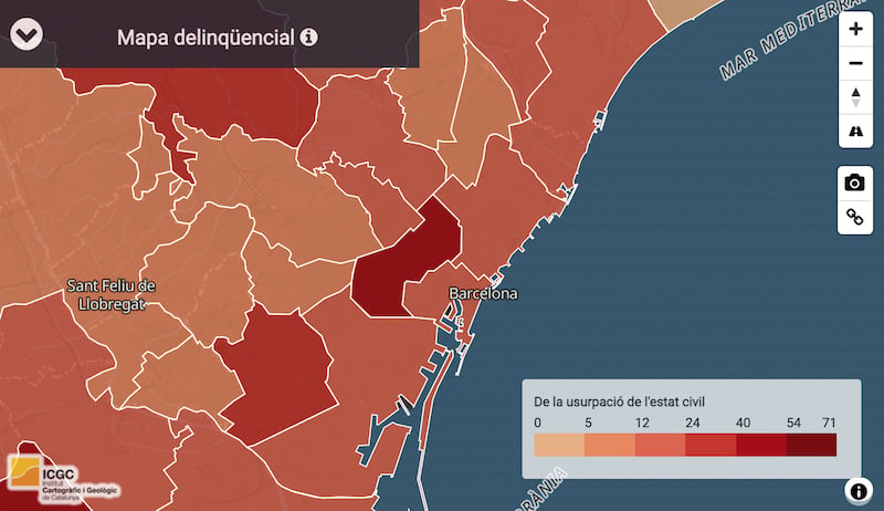
Barcelona has a crime problem
It will come as no surprise to discover that Barcelona sees more than its fair share of petty crimes, but it may be interesting to see where most of them take place.
Contrary to popular opinion that most of them take place in places like the Gothic Quarter and Raval, the map shows that more actually take place in Eixample.
Advertisement
This is followed by the neighbouring town of L'Hospitalet de Llobregat. The districts with the least amount of crime in Barcelona are Sant Andreu, Nou Barris, Les Corts and Sarrià-Sant Gervasi. Click here if you want to access the zoomable map.
A crime map of the city of Barcelona. Source: Mossos d Esquadra | Institut Cartogràfic i Geològic de Catalunya
Barcelona has grown enormously over the past century
It's crazy to think how big Barcelona is now to what it was a century ago.
This incredible downloadable map by physical geographer Dr. Dominic Royé shows all the various parts of the city and when they were created, from those prior to 1890 all the way up to those built after the year 2000. The oldest parts of the city are of course in the centre, while the newest areas are around the Barcelona Forum, where there are lots of modern hotels and apartment buildings.
Barcelona has grown exponentially over the past 130 years. Source: Dominic Royé (Twitter: @dr_xeo)
Barcelona is a great city for cycling
Barcelona is a great place for cycling with over 230km of dedicated lanes crisscrossing he city.
Advertisement
Over 100 of these have been built within the last six years. In fact, more than 90 percent of Barcelona residents live within 300m of a cycle lane and the City Council hopes to more than double the number of journeys people make by bike in the city 2024.
Cycle lane map of Barcelona. Source: Ajuntament de Barcelona
Each neighbourhood has its own clichés
You may have formed your own opinion of certain areas of Barcelona, but these are words that residents of the city have used to describe various neighbourhoods.
It was created by Hoodmaps, which features may maps of cities all over the world. It lists words like 'pickpockets' near the Rambla or 'tourist trap' for some areas in the centre, while outer-lying neighbourhoods like Sant Andreu is described as 'residential area, very calm'.
A map showing people's opinions of different areas in Barcelona. Source: Hoodmaps
Join the conversation in our comments section below. Share your own views and experience and if you have a question or suggestion for our journalists then email us at [email protected].
Please keep comments civil, constructive and on topic – and make sure to read our terms of use before getting involved.
 Barcelona is made up of 10 different districts. Source: Ajuntament de Barcelona
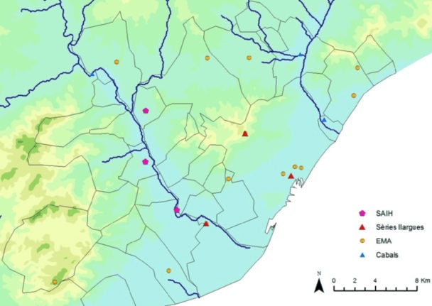 Barcelona is built between two rivers. Source: l'AMB
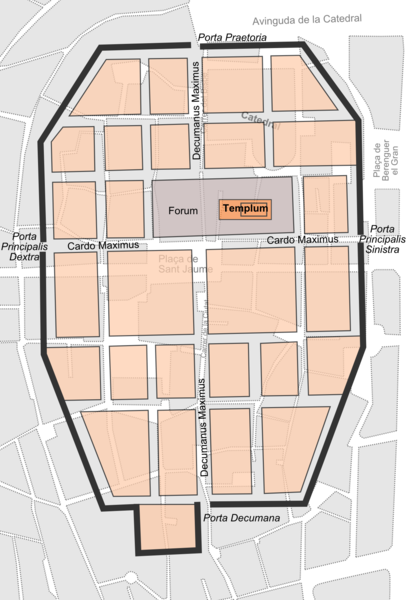 Roman Barcelona, known as Barcino. Source: Ajuntament de Barcelona
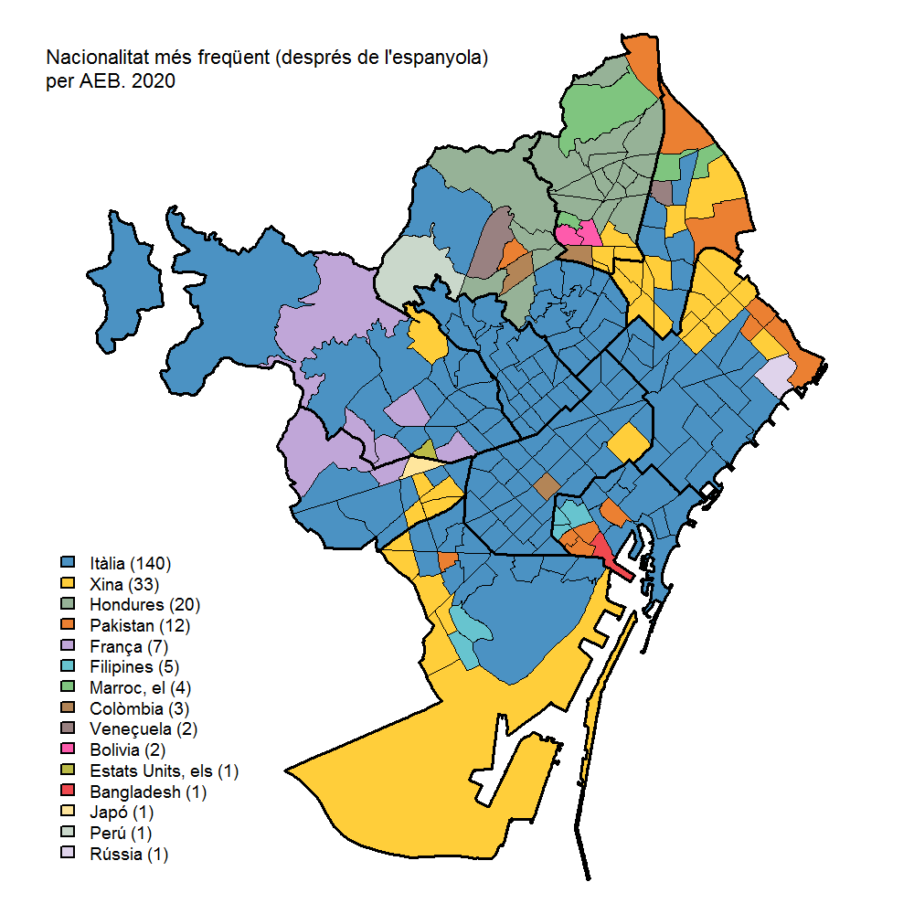 The most frequent nationality in each district of Barcelona, after Spanish. Source: Ajuntament de Barcelona
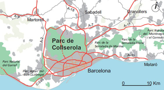 The Collserola is a natural park within the city of Barcelona. Source: parccollserola.net
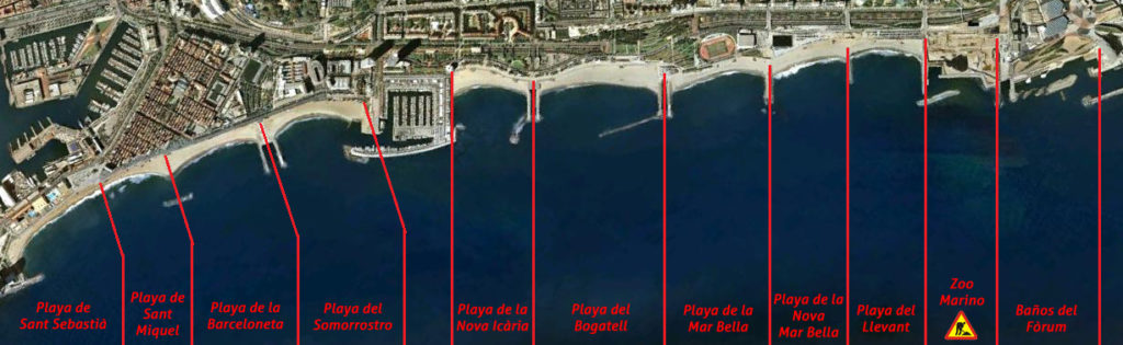 Barcelona's eight beaches together with the Fòrum bathing area at the very end of the map. Source: Javiergp89/Wikipedia
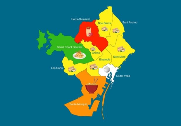 Which takeaway dish does each district in Barcelona prefer? Source: Just Eat
Barcelona has a crime problem
It will come as no surprise to discover that Barcelona sees more than its fair share of petty crimes, but it may be interesting to see where most of them take place.
Contrary to popular opinion that most of them take place in places like the Gothic Quarter and Raval, the map shows that more actually take place in Eixample.
This is followed by the neighbouring town of L'Hospitalet de Llobregat. The districts with the least amount of crime in Barcelona are Sant Andreu, Nou Barris, Les Corts and Sarrià-Sant Gervasi. Click here if you want to access the zoomable map.
Which takeaway dish does each district in Barcelona prefer? Source: Just Eat
Barcelona has a crime problem
It will come as no surprise to discover that Barcelona sees more than its fair share of petty crimes, but it may be interesting to see where most of them take place.
Contrary to popular opinion that most of them take place in places like the Gothic Quarter and Raval, the map shows that more actually take place in Eixample.
This is followed by the neighbouring town of L'Hospitalet de Llobregat. The districts with the least amount of crime in Barcelona are Sant Andreu, Nou Barris, Les Corts and Sarrià-Sant Gervasi. Click here if you want to access the zoomable map.
 A crime map of the city of Barcelona. Source: Mossos d Esquadra | Institut Cartogràfic i Geològic de Catalunya
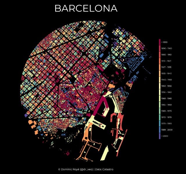 Barcelona has grown exponentially over the past 130 years. Source: Dominic Royé (Twitter: @dr_xeo)
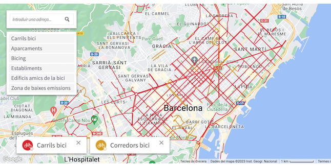 Cycle lane map of Barcelona. Source: Ajuntament de Barcelona
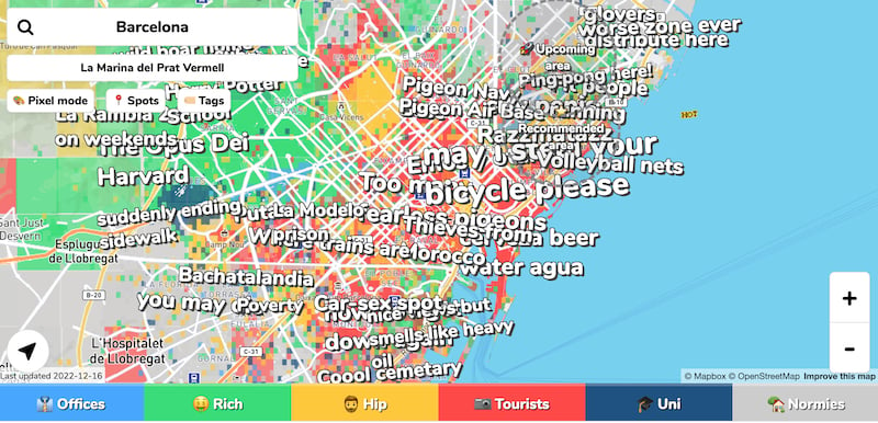 A map showing people's opinions of different areas in Barcelona. Source: Hoodmaps
Join the conversation in our comments section below. Share your own views and experience and if you have a question or suggestion for our journalists then email us at [email protected].
Please keep comments civil, constructive and on topic – and make sure to read our terms of use before getting involved.
Please log in here to leave a comment.