IN IMAGES: Spain hit by heavy rain, floods and hurricane-force winds
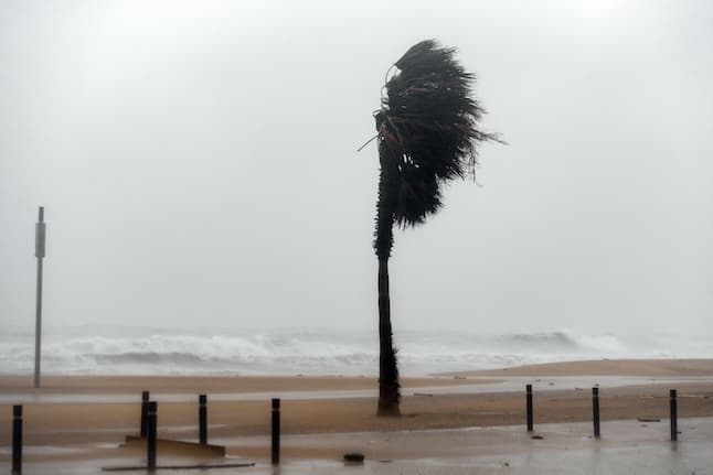
The arrival of Storm Efraín has already seen parts of Spain experience heavy rainfall, flooding and strong winds, with 35 provinces currently on alert and more of the same weather forecast for Tuesday and the rest of week.
Most of Spain may not have the festive snowfall that much of northern Europe currently has, but it will experience heavy rains and possible flooding over the next week instead.
There will be "abundant rainfall" throughout the country, especially in the south and west of the peninsula, Spain's State Meteorological agency AEMET reported on Monday, warning that there could be up to 80 litres of rain in just 12 hours in some areas and more than 100 litres in 48 hours.
Tuesday and Wednesday will be two of the worst days according to the agency, especially in the southern interior of the Spanish mainland. As the videos below reflect, some of these areas already experienced heavy rainfall and floods on Sunday and Monday.
A total of 35 provinces are now on alert for heavy rain, strong wind and big waves.
N-523 entre Cáceres y Badajoz arrasada. A ver si con esto nos hacen autovía de una vez. @sextaNoticias pic.twitter.com/gmpGM1vxcG
— EricWhite (@eric_cpc) December 13, 2022
Galicia will be one of the worst-affected regions, but heavy rain will also fall across Extremadura, Andalusia, Castilla-La Mancha, Madrid and Aragón.
Affected regions will all see double the amount of rain than is normal for this time of year, AEMET stated.
There will be "very abundant and very welcome" rainfall in areas particularly hard hit by drought, explained spokesman for AEMET Rubén del Campo.
The areas of Huelva, Extremadura and Grazalema in Andalusia experienced flooding and high winds over the weekend, but the conditions are expected to continue into the rest of this week too.
Las Capellanias. pic.twitter.com/OCZoCtTAVW
— Antonio Hernández (@HerndezAntonio) December 13, 2022
🔴#7TV ALERTA NARANJA en la provincia. Decenas de salidas de bomberos por inundaciones de viviendas, calles y garajes. Sin daños personales. En #Grazalema ya han caído más de 120 litros por metro cuadrado pic.twitter.com/AwGulNb9Bu
— 7 TV Cádiz (@7TVCadiz) December 9, 2022
The rest of the peninsula, along with the Balearic Islands, will also see lots of rain this week but are not at risk for flooding.
The arrival of storm Efraín will also bring with it higher temperatures, allowing Spain to escape the colder temperatures of northern and central Europe.
Inundaciones en la Roca de la Sierra (Badajoz) autor desconocido. @Tiempo_Mercedes @MeteoredES @tiempobrasero pic.twitter.com/yInvjB3bBw
— Miguel Angel N. Martinez 🌨🌞🌪🌬⛈❄ (@peska007oficial) December 13, 2022
According to AEMET, there will be a "notable rise" in temperatures on Tuesday December 13th which could see some areas even reach 24C.
El Río Guadiamar cruje a lo lindo a su paso por Gerena #Sevilla.
Toda esta agua sirve para llenar las Marismas de Doñana.
¡Aguaaa vaaa! pic.twitter.com/qtqNAYlAbo
— MeteoGerena (Sevilla) (@MeteoGerena) December 11, 2022
Minimum temperatures could be up to 10C or more above what is normal for this time of year due to warm air being blown in from sub-tropical origin. A maximum of 24C is forecast in Murcia, 23C in Alicante and 22C in Valencia.
Even places like Bilbao and Toledo could see a temperature rise up to 19C. Eastern Andalusian cities may also see the mercury rise to 20C.
Comments
See Also
Most of Spain may not have the festive snowfall that much of northern Europe currently has, but it will experience heavy rains and possible flooding over the next week instead.
There will be "abundant rainfall" throughout the country, especially in the south and west of the peninsula, Spain's State Meteorological agency AEMET reported on Monday, warning that there could be up to 80 litres of rain in just 12 hours in some areas and more than 100 litres in 48 hours.
Tuesday and Wednesday will be two of the worst days according to the agency, especially in the southern interior of the Spanish mainland. As the videos below reflect, some of these areas already experienced heavy rainfall and floods on Sunday and Monday.
A total of 35 provinces are now on alert for heavy rain, strong wind and big waves.
N-523 entre Cáceres y Badajoz arrasada. A ver si con esto nos hacen autovía de una vez. @sextaNoticias pic.twitter.com/gmpGM1vxcG
— EricWhite (@eric_cpc) December 13, 2022
Galicia will be one of the worst-affected regions, but heavy rain will also fall across Extremadura, Andalusia, Castilla-La Mancha, Madrid and Aragón.
Affected regions will all see double the amount of rain than is normal for this time of year, AEMET stated.
There will be "very abundant and very welcome" rainfall in areas particularly hard hit by drought, explained spokesman for AEMET Rubén del Campo.
The areas of Huelva, Extremadura and Grazalema in Andalusia experienced flooding and high winds over the weekend, but the conditions are expected to continue into the rest of this week too.
Las Capellanias. pic.twitter.com/OCZoCtTAVW
— Antonio Hernández (@HerndezAntonio) December 13, 2022
🔴#7TV ALERTA NARANJA en la provincia. Decenas de salidas de bomberos por inundaciones de viviendas, calles y garajes. Sin daños personales. En #Grazalema ya han caído más de 120 litros por metro cuadrado pic.twitter.com/AwGulNb9Bu
— 7 TV Cádiz (@7TVCadiz) December 9, 2022
The rest of the peninsula, along with the Balearic Islands, will also see lots of rain this week but are not at risk for flooding.
The arrival of storm Efraín will also bring with it higher temperatures, allowing Spain to escape the colder temperatures of northern and central Europe.
Inundaciones en la Roca de la Sierra (Badajoz) autor desconocido. @Tiempo_Mercedes @MeteoredES @tiempobrasero pic.twitter.com/yInvjB3bBw
— Miguel Angel N. Martinez 🌨🌞🌪🌬⛈❄ (@peska007oficial) December 13, 2022
According to AEMET, there will be a "notable rise" in temperatures on Tuesday December 13th which could see some areas even reach 24C.
El Río Guadiamar cruje a lo lindo a su paso por Gerena #Sevilla.
— MeteoGerena (Sevilla) (@MeteoGerena) December 11, 2022
Toda esta agua sirve para llenar las Marismas de Doñana.
¡Aguaaa vaaa! pic.twitter.com/qtqNAYlAbo
Minimum temperatures could be up to 10C or more above what is normal for this time of year due to warm air being blown in from sub-tropical origin. A maximum of 24C is forecast in Murcia, 23C in Alicante and 22C in Valencia.
Even places like Bilbao and Toledo could see a temperature rise up to 19C. Eastern Andalusian cities may also see the mercury rise to 20C.
Join the conversation in our comments section below. Share your own views and experience and if you have a question or suggestion for our journalists then email us at [email protected].
Please keep comments civil, constructive and on topic – and make sure to read our terms of use before getting involved.
Please log in here to leave a comment.