In Images: Torrential rain puts eastern Spain on high flood alert
Many parts of Almería, Alicante, Valencia and Murcia will get 90 litres of rain per square metre in just an hour on Thursday, with videos posted online already showing the destruction being caused by the storms.
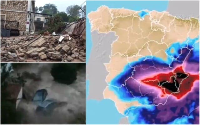
Summer in Spain appears to be well and truly over with the arrival of a cold front that is currently wreaking havoc in many of country’s eastern regions.
The “gota fría”, as this meteorological phenomenon is called in Spanish, has brought with it very heavy rainfall, hail, winds of up to 100km/h and huge waves along mainland Spain’s eastern belt.
The Mediterranean regions of Almería, Alicante, Valencia and Murcia are currently bearing the brunt of the storm – and are all on high alert for extreme weather.
In fact, it’s the first time since 2007 that Spain’s weather agency AEMET has activated a double alert for both rainfall and storms, as this dangerous cold front has the potential to generate two-centimetre wide hailstones, gale-force winds of up to 100km/h and even tornadoes.
Vale, acaba de cruzar por delante de mi casa un pequeño tornado. Todo bien #gotafria #DANAseptiembre #GuardamarDelSegura @ElTiempoes @Meteoalicante1 @ElTiempo_tve pic.twitter.com/Vybc85Y1sI
— Fernando Herranz (@fer_hist) September 12, 2019
#DANAsetembre: situació de la via del tren a la Font de la Figuera (la Costera, València), convertida en un autèntic riu. En aquesta zona s'han acumulat fins a les 10h més de 200mm. pic.twitter.com/v0AC8GLYNd
— AVAMET (@avamet) September 12, 2019
Meteorologists are forecasting 60 to 90 litres of rainfall per sqm to come pouring down in just 60 minutes in some areas, and 200 litres/sqm overall on Thursday.
#DANAsetembre: més imatges tremendes, cotxes arrossegats per la Rambla del Bosquet a #Moixent (la Costera, València) pic.twitter.com/j5X81OFQhq
— AVAMET (@avamet) September 12, 2019
¡Continúa el aviso rojo (riesgo extremo) por lluvias muy intensas en gran parte del sureste peninsular! Esta mañana (12/09/2019), #RíoClariano desbordado a su paso por #Ontinyent (#Valencia). Vídeo: @Batalleta. pic.twitter.com/22A3Z5zTKf
— MeteOrihuela (@MeteOrihuela) September 12, 2019
The Valencian municipality of Ontinyent has experienced some the worst weather thus far, with more than 250 litres of rainfall/sqm in just 24 hours, causing the Clariano river that runs through it to break its banks. The Valencian village of Moixent (seen above) has also been badly hit, with cars being dragged downstream by the floods.
Los datos de la red de @avamet hasta ahora en la #ComunitatValenciana lo dicen todo ... algunos observatorios como #Beniarrés en la comarca de El Comtat lo dicen todo ... brutales cantidades de agua y aún queda #DANAseptiembre #gotafria #Lluvia #Dana #tormentas pic.twitter.com/gJesfsZVUZ
— Mario Picazo (@picazomario) September 12, 2019
The weather along and around Spain’s eastern coastline initially took a turn for the worse on Monday night, but it was on Wednesday that the storms really began to cause serious problems.
Evolución previsible de las lluvias en los próximos días. Especialmente intensas en la zona de Levante. Impresiona #GotaFría pic.twitter.com/MP4WIBTd6F
— Tomás García Castro ?? (@tomasgarciacast) September 11, 2019
Social media users have started sharing videos of the biblical storms punishing their neighbourhoods.
Floods are also affecting areas of Spain that are further inland, such as the city Albacete in Castilla y La Mancha.
⛈ Así está la A-31 a la altura de Bonete #Albacete. Las balsas de agua han obligado a cortar la vía a la altura de Caudete. @InformacionDGT #gotafria pic.twitter.com/Qbz0zvftEN
— RTVEcastillalamancha (@RTVEclm) September 12, 2019
We will continue to update this page with more photos and footage from people caught in this very rare weather phenomenon.
En #Moixent comarca de #laCostera interior sur de #Valencia el cielo se ha desplomado y las montañas de alrededor han recogido mucha agua ... así baja por sus calles mientras sigue diluviando #DANA #lluvias #tormentas #GotaFría pic.twitter.com/8gzn0a8bDn
— Mario Picazo (@picazomario) September 12, 2019
Primeres incidències a Agullent @apuntoratge @avamet pic.twitter.com/OhKKVwk5Aj
— Pau Roig i Tortosa (@pauroigBQ) September 12, 2019
El riu canyoles a seu pas per vallada! ???@oratgenet @avamet @AEMET_CValencia @AEMET_Esp @apuntoratge @oratgeRTVV @l_oratge @oratge_LTV @TV_Comarcal pic.twitter.com/Yfwvm5Tc0U
— Enrique sanchis (@wiket1987) September 12, 2019
Comments
See Also
Summer in Spain appears to be well and truly over with the arrival of a cold front that is currently wreaking havoc in many of country’s eastern regions.
The “gota fría”, as this meteorological phenomenon is called in Spanish, has brought with it very heavy rainfall, hail, winds of up to 100km/h and huge waves along mainland Spain’s eastern belt.
The Mediterranean regions of Almería, Alicante, Valencia and Murcia are currently bearing the brunt of the storm – and are all on high alert for extreme weather.
In fact, it’s the first time since 2007 that Spain’s weather agency AEMET has activated a double alert for both rainfall and storms, as this dangerous cold front has the potential to generate two-centimetre wide hailstones, gale-force winds of up to 100km/h and even tornadoes.
Vale, acaba de cruzar por delante de mi casa un pequeño tornado. Todo bien #gotafria #DANAseptiembre #GuardamarDelSegura @ElTiempoes @Meteoalicante1 @ElTiempo_tve pic.twitter.com/Vybc85Y1sI
— Fernando Herranz (@fer_hist) September 12, 2019
#DANAsetembre: situació de la via del tren a la Font de la Figuera (la Costera, València), convertida en un autèntic riu. En aquesta zona s'han acumulat fins a les 10h més de 200mm. pic.twitter.com/v0AC8GLYNd
— AVAMET (@avamet) September 12, 2019
Meteorologists are forecasting 60 to 90 litres of rainfall per sqm to come pouring down in just 60 minutes in some areas, and 200 litres/sqm overall on Thursday.
#DANAsetembre: més imatges tremendes, cotxes arrossegats per la Rambla del Bosquet a #Moixent (la Costera, València) pic.twitter.com/j5X81OFQhq
— AVAMET (@avamet) September 12, 2019
¡Continúa el aviso rojo (riesgo extremo) por lluvias muy intensas en gran parte del sureste peninsular! Esta mañana (12/09/2019), #RíoClariano desbordado a su paso por #Ontinyent (#Valencia). Vídeo: @Batalleta. pic.twitter.com/22A3Z5zTKf
— MeteOrihuela (@MeteOrihuela) September 12, 2019
The Valencian municipality of Ontinyent has experienced some the worst weather thus far, with more than 250 litres of rainfall/sqm in just 24 hours, causing the Clariano river that runs through it to break its banks. The Valencian village of Moixent (seen above) has also been badly hit, with cars being dragged downstream by the floods.
Los datos de la red de @avamet hasta ahora en la #ComunitatValenciana lo dicen todo ... algunos observatorios como #Beniarrés en la comarca de El Comtat lo dicen todo ... brutales cantidades de agua y aún queda #DANAseptiembre #gotafria #Lluvia #Dana #tormentas pic.twitter.com/gJesfsZVUZ
— Mario Picazo (@picazomario) September 12, 2019
The weather along and around Spain’s eastern coastline initially took a turn for the worse on Monday night, but it was on Wednesday that the storms really began to cause serious problems.
Evolución previsible de las lluvias en los próximos días. Especialmente intensas en la zona de Levante. Impresiona #GotaFría pic.twitter.com/MP4WIBTd6F
— Tomás García Castro ?? (@tomasgarciacast) September 11, 2019
Social media users have started sharing videos of the biblical storms punishing their neighbourhoods.
Floods are also affecting areas of Spain that are further inland, such as the city Albacete in Castilla y La Mancha.
⛈ Así está la A-31 a la altura de Bonete #Albacete. Las balsas de agua han obligado a cortar la vía a la altura de Caudete. @InformacionDGT #gotafria pic.twitter.com/Qbz0zvftEN
— RTVEcastillalamancha (@RTVEclm) September 12, 2019
We will continue to update this page with more photos and footage from people caught in this very rare weather phenomenon.
En #Moixent comarca de #laCostera interior sur de #Valencia el cielo se ha desplomado y las montañas de alrededor han recogido mucha agua ... así baja por sus calles mientras sigue diluviando #DANA #lluvias #tormentas #GotaFría pic.twitter.com/8gzn0a8bDn
— Mario Picazo (@picazomario) September 12, 2019
Primeres incidències a Agullent @apuntoratge @avamet pic.twitter.com/OhKKVwk5Aj
— Pau Roig i Tortosa (@pauroigBQ) September 12, 2019
El riu canyoles a seu pas per vallada! ???@oratgenet @avamet @AEMET_CValencia @AEMET_Esp @apuntoratge @oratgeRTVV @l_oratge @oratge_LTV @TV_Comarcal pic.twitter.com/Yfwvm5Tc0U
— Enrique sanchis (@wiket1987) September 12, 2019
Join the conversation in our comments section below. Share your own views and experience and if you have a question or suggestion for our journalists then email us at [email protected].
Please keep comments civil, constructive and on topic – and make sure to read our terms of use before getting involved.
Please log in here to leave a comment.