In Pictures: Tidal waves crush northern Spain
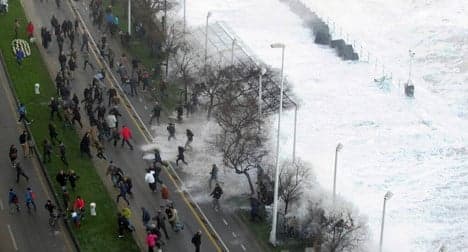
Spain's northern coast hasn't seen the last of the destructive tidal waves and gale-force winds that have caused havoc over the past few days. Storm Petra is now on its way, a freak weather occurrence labelled by meteorologists as an "explosive cyclogenesis": the perfect storm.
If you live in northern Spain, you probably know already it's not the right time to go for a dip in the sea.
Eleven-metre tidal waves (36 feet) and winds of up to 100 kilometres per hour (63mph) have been recorded in Galicia, Asturias, Cantabria and the Basque Country.
Even inland northern Spanish regions like La Rioja and Navarre have also felt the effects of a vicious storm which on Monday swept a teenager out to sea in A Coruña (Galicia).
But the worst is yet to come.
Spain’s official weather agency AEMET has put out a warning about the arrival on Wednesday of Storm Petra, a huge low-pressure area that will quickly form as it’s met by several cold Atlantic fronts.
The result? Even bigger waves, winds of up to 140 kilometres per hour and a sudden drop in temperatures.
Here are some of the most jaw-dropping storm photos posted by Twitter users over the past few days. We’ll update the selection as new images of Storm Petra come in.
Wrap up and enjoy!
Gran socavón en la carretera del faro de #Hondarribia tras nuevo derrumbe donde hace unos días. Vía @HondarribiaUdal pic.twitter.com/U7SYOjvVNY
— Joel Iglesias (@Joel_Iglesias) February 2, 2014
Mucho ánimo a los afectados, desde Galicia al País Vasco, por el temporal de este fin de semana. Foto @gorkazabaleta pic.twitter.com/6zzQqVrcdp
— ACT Liga San Miguel (@actraineras) February 3, 2014
Esta foto la verdad me dejo sin palabras !!!! #gijon #asturias @QHacerEnGijon @asturguia @TPAnoticias @conexiontpa pic.twitter.com/bYN8KW58Ay
— By Xana (@x4n4xana) February 5, 2014
La fuerza del mar en #Gijón da verdadero miedo pic.twitter.com/em9ckPvBHl
— Leticia Zapico Pico (@lzapicopico) February 2, 2014
Impresionante imagen temporal del norte: Isla de Mouro bocana puerto de Santander por Esteban Cobo EFE. pic.twitter.com/3KVpjS1mY2
— José Luis González (@josslu9) February 4, 2014
Así azotan hoy las olas en San Lorenzo (#Gijón). La mar sigue brava y Asturias, en alerta por fenomenos costeros pic.twitter.com/SaGGVvdadk
— Onda Cero Gijón (@ondacerogijon) February 5, 2014
Mas olas... http://t.co/0NMlKOpTT8 pic.twitter.com/uqUYhZ5uiR
— salaciencia (@salacienciaTL) February 2, 2014
La borrasca -Petra- ya tiene la potencia de un huracán Categoría 1, aunque su proceso NO tiene nada que ver. pic.twitter.com/OdPLnsAzhe
— JonathanGómezCantero (@JG_Cantero) February 4, 2014
Surfeando http://t.co/0NMlKOpTT8 pic.twitter.com/DV7FfZfXc0
— salaciencia (@salacienciaTL) February 2, 2014
Comments
See Also
If you live in northern Spain, you probably know already it's not the right time to go for a dip in the sea.
Eleven-metre tidal waves (36 feet) and winds of up to 100 kilometres per hour (63mph) have been recorded in Galicia, Asturias, Cantabria and the Basque Country.
Even inland northern Spanish regions like La Rioja and Navarre have also felt the effects of a vicious storm which on Monday swept a teenager out to sea in A Coruña (Galicia).
But the worst is yet to come.
Spain’s official weather agency AEMET has put out a warning about the arrival on Wednesday of Storm Petra, a huge low-pressure area that will quickly form as it’s met by several cold Atlantic fronts.
The result? Even bigger waves, winds of up to 140 kilometres per hour and a sudden drop in temperatures.
Here are some of the most jaw-dropping storm photos posted by Twitter users over the past few days. We’ll update the selection as new images of Storm Petra come in.
Wrap up and enjoy!
Gran socavón en la carretera del faro de #Hondarribia tras nuevo derrumbe donde hace unos días. Vía @HondarribiaUdal pic.twitter.com/U7SYOjvVNY
— Joel Iglesias (@Joel_Iglesias) February 2, 2014 Mucho ánimo a los afectados, desde Galicia al País Vasco, por el temporal de este fin de semana. Foto @gorkazabaleta pic.twitter.com/6zzQqVrcdp
— ACT Liga San Miguel (@actraineras) February 3, 2014 Esta foto la verdad me dejo sin palabras !!!! #gijon #asturias @QHacerEnGijon @asturguia @TPAnoticias @conexiontpa pic.twitter.com/bYN8KW58Ay
— By Xana (@x4n4xana) February 5, 2014 La fuerza del mar en #Gijón da verdadero miedo pic.twitter.com/em9ckPvBHl
— Leticia Zapico Pico (@lzapicopico) February 2, 2014 Impresionante imagen temporal del norte: Isla de Mouro bocana puerto de Santander por Esteban Cobo EFE. pic.twitter.com/3KVpjS1mY2
— José Luis González (@josslu9) February 4, 2014 Así azotan hoy las olas en San Lorenzo (#Gijón). La mar sigue brava y Asturias, en alerta por fenomenos costeros pic.twitter.com/SaGGVvdadk
— Onda Cero Gijón (@ondacerogijon) February 5, 2014 Mas olas... http://t.co/0NMlKOpTT8 pic.twitter.com/uqUYhZ5uiR
— salaciencia (@salacienciaTL) February 2, 2014 La borrasca -Petra- ya tiene la potencia de un huracán Categoría 1, aunque su proceso NO tiene nada que ver. pic.twitter.com/OdPLnsAzhe
— JonathanGómezCantero (@JG_Cantero) February 4, 2014
Surfeando http://t.co/0NMlKOpTT8 pic.twitter.com/DV7FfZfXc0
— salaciencia (@salacienciaTL) February 2, 2014
Join the conversation in our comments section below. Share your own views and experience and if you have a question or suggestion for our journalists then email us at [email protected].
Please keep comments civil, constructive and on topic – and make sure to read our terms of use before getting involved.
Please log in here to leave a comment.